View current bins
Main menu
  • Search
  • About
  • News
  • Services
  • Contact
Secondary Menu
  • Log in
  • Register

Video URL
Add to clip bin

Download Preview

13162_26930_texas_expansion1
Subjects
U.S. Geography
History

Keywords
United States,
map,
Mexico,
mexican-american war,
1846,
1847,
history,
animated
1977
Color

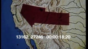
Animated map of the United States. A white line indicates the Mexican and U.S. territory between 1846 and 1847. Yellow arrow indicates the routes the U.S. took into Mexico during the Mexican-American War.


Related Clips


Add to clip bin

1970s

13162_27246_cal_exped

Animated map of the United States. What was Mexican property before the…
Add to clip bin

1960s

13162_28937_mexican_war2

Animated map of the United States, Mexico, Mexico City, French Louisiana…
Add to clip bin

1960s

13162_28937_mexican_war1

Animated map of the United States. The Republic of Texas or Tejas is…
Add to clip bin

1970s

13162_26930_texas_expansion2

United States and Mexico map showing the change in territorial boundaries…

Stay Connected

  • Follow us on Facebook
  • Follow us on Twitter
  • Follow us on Instagram
  • Contact Us

All contents © 2025 . All Rights Reserved.

Footer menu
  • Privacy Policy
  • Terms of Use